AERIAL REAL ESTATE PHOTOGRAPHY
SPECIAL OFFER FOR REALTORS: GET YOUR NEXT AERIAL PHOTO PACKAGE ($199 VALUE) FOR FREE!
DRONE-PIC-1099 LLC is a certified member of the Sky Eye Network and a professional Aerial Real Estate Photographer. As a professional Aerial Real Estate Photographer, we can help you sell your home faster, and for more money. There are four main advantages to using Aerial photography.
Four Ways Aerial Real Estate Photography Benefits Realtors:
ONE—Aerial photography reduces days on the market by 32% on average. TWO—they result in a higher sales price, about 5.25% on average. THREE—aerial photography highlights property features, landmarks, and amenities that a regular ground level shot could never show. FOUR—Aerial photographs create a higher perceived value of both the property and the Realtor.
To see exactly how our services can benefit you, we’d like to give you your very first aerial photo shoot for your next listing, absolutely FREE. There is no obligation, so you’ve got nothing to lose. To take advantage of this special offer, simply call (316) 368-2106 or fill out the form.
Request Your FREE Aerial Photo Shoot (for Realtors only)
By signing up via text, you agree to receive recurring automated marketing messages, including cart reminders, at the phone number provided. Consent is not a condition of purchase. Reply STOP to unsubscribe. Message frequency varies. Msg & data rates may apply. Your Privacy is our priority. Your information will not be shared.
CALL DRONE-PIC-1099 LLC TODAY:
(316) 368-2106
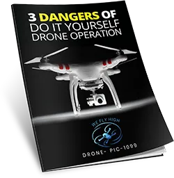
Click on the image above to Download this special report, “3 Dangers of Do It Yourself Drone Operation” for FREE from DRONE-PIC-1099 LLC!
CONTACT US:
DRONE-PIC-1099 LLC
PO Box 225
Andover, Kansas 67002
Disclaimer:
The mapping and aerial imaging services provided by DRONE-PIC-1099 LLC are intended solely for informational, planning, visualization, and project management purposes. These services do not establish, re-establish, or define property boundaries, easements, or legal land divisions. The deliverables, including but not limited to orthomosaics, 3D models, point clouds, or topographic maps, are not certified surveys and should not be used as legal documents. For any official boundary or land surveying needs, please consult a licensed Kansas Professional Surveyor.
© 2026 | DRONE-PIC-1099 LLC. All Rights Reserved
Member of the Sky Eye Network